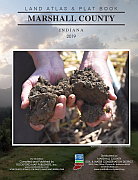
 The 2019 Marshall County Land Atlas and Plat Book is now available. This newest edition published by Rockford Map Publishers is available for purchase from the Marshall County Soil & Water Conservation District, 2903 Gary Drive, Plymouth.
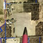
The new plat book accurately displays parcel boundaries, acreage data, roadways, waterways, railways, section lines, municipal boundaries, recreational areas, and includes an index to landowners. A3D aerial map lies opposite each township parcel map, and is very useful in providing a quick gauge to the use of a particular parcel.
Plat books are a great reference tool for landowners and business owners. It is a necessary reference guide for industries such as agriculture, land development, hunting, real estate, utilities, municipal government, and more.
To purchase additional products, visit RockfordMap.com for plat books, wall maps, and a variety of digital map products from counties all over the country. Call 815-708-6324 for more information.