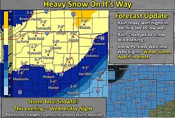
The Winter Storm Watch remain in effect beginning this evening and continuing through Wednesday Night. The system has shifted to the south which means that we are in the area that will receive the heaviest amount of snow. Snow accumulations in excess of 6 inches are possible.
Winds will increase Wednesday out of the north at 15-20 mph with gusts up to 25 mph which will cause blowing and drifting issues particularly in open areas throughout the county.
Lake effect snow will kick in on Thursday with additional accumulation likely.
We can expect hazardous driving conditions caused by snow covered roads, reduced visibility, and drifting across roads will likely lead to an increase in the number of slide-offs and traffic accidents.
Drivers are urged to slow down and allow yourself extra time reach your destination. Increase your following distance to give yourself plenty of room to take evasive actions if needed. Be mindful of the potential for poor visibility and for large snow drifts across roads. If you don’t need to be out, don’t go.